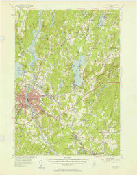
1956 Map of Lewiston
USGS Topo · Published 1958About this map
The Androscoggin River serves as the industrial and geographic spine of this mid-century Maine landscape, dividing the urban centers of Lewiston and Auburn. The core of Lewiston is densely developed, featuring the campus of Bates College and landmarks like Mt David. To the south and east, the character of the land shifts toward a rural economy marked by scattered hamlets such as South Lewiston and Webster Corner.
Find a feature on this map
147 named features on this map. Tap any name to fly to it.
Don’t see what you’re looking for? This feature index may not catch every label — zoom into the map to look around manually.
Map Details
Editions of this 1956 Lewiston Map
4 editions found
Other maps of this area

1892 · Gardiner
USGS Topo · 1:62,500

1892 · Freeport
USGS Topo · 1:62,500

1892 · Augusta
USGS Topo · 1:62,500

1894 · Gray
USGS Topo · 1:62,500

1894 · Bath
USGS Topo · 1:62,500

1898 · Gray
USGS Topo · 1:62,500

1908 · Poland
USGS Topo · 1:62,500

1908 · Lewiston
USGS Topo · 1:62,500

1910 · Livermore
USGS Topo · 1:62,500

1911 · Buckfield
USGS Topo · 1:62,500