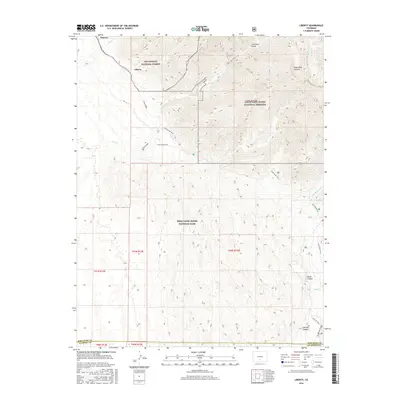
2016 Map of Liberty
USGS Topo · Published 2016About this map
Great Sand Dunes National Park and the adjacent Great Sand Dunes National Preserve dominate the southern and central landscape of this 2016 survey. The transition from the massive dune fields to the high peaks of the Rio Grande National Forest is clearly visible, with the northern edge of the map showing the small settlements of Liberty and Duncan near the mouth of Pole Cr. The map details a complex network of ephemeral watercourses and canyons, such as Cleveland Gulch and Horse Canyon, that drain into the basin. This area is a critical junction of wilderness and public lands, where the Sand Ramp Trail skirts the eastern edge of the dunes. For those studying the history of the Sangre de Cristo foothills, the map provides precise locations for these early foothill settlements and the drainage patterns of Sand Cr and Medano Cr as they emerge from the mountains.
Find a feature on this map
28 named features on this map. Tap any name to fly to it.
Don’t see what you’re looking for? This feature index may not catch every label — zoom into the map to look around manually.
Map Details
Editions of this 2016 Liberty Map
This is the sole edition of this map. No revisions or reprints were ever made.
Other maps of this area

1889 · Huerfano Park
USGS Topo · 1:125,000

1892 · Huerfano Park
USGS Topo · 1:125,000

1954 · Trinidad
USGS Topo · 1:250,000

1955 · Trinidad
USGS Topo · 1:250,000

1958 · Trinidad
USGS Topo · 1:250,000

1959 · Trinidad
USGS Topo · 1:250,000
1960 · Beck Mountain
USGS Topo · 1:24,000

1965 · Medano Ranch
USGS Topo · 1:24,000

1965 · Zapata Ranch
USGS Topo · 1:24,000
1967 · Crestone
USGS Topo · 1:24,000