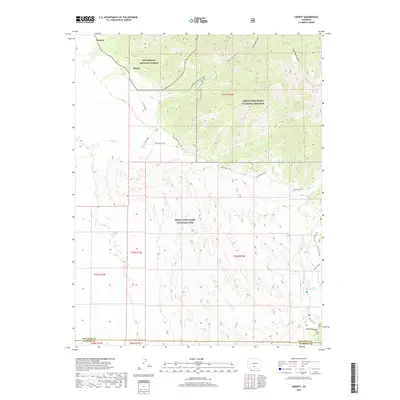
2019 Map of Liberty
USGS Topo · Published 2019About this map
Liberty and Duncan represent the principal human settlements in this high-altitude landscape where the Sangre de Cristo Mountains meet the San Luis Valley. This topographic record documents the complex transition from the protected woodlands of the Rio Grande National Forest to the shifting landscapes of the Great Sand Dunes National Park and Great Sand Dunes National Preserve. The hydrology of the area is defined by seasonal watercourses like Sand Creek and Medano Creek, which interact with the massive dune field. A network of primitive routes, including the Sand Ramp Trail and various stretches of 2 Track Road, provides the only access through this wilderness. Notable geological features such as Cleveland Gulch, Slide Rock Canyon, and Sawmill Canyon highlight the steep drainage patterns that feed the valley floor below.
Find a feature on this map
65 named features on this map. Tap any name to fly to it.
Don’t see what you’re looking for? This feature index may not catch every label — zoom into the map to look around manually.
Map Details
Editions of this 2019 Liberty Map
This is the sole edition of this map. No revisions or reprints were ever made.
Other maps of this area

1889 · Huerfano Park
USGS Topo · 1:125,000

1892 · Huerfano Park
USGS Topo · 1:125,000

1954 · Trinidad
USGS Topo · 1:250,000

1955 · Trinidad
USGS Topo · 1:250,000

1958 · Trinidad
USGS Topo · 1:250,000

1959 · Trinidad
USGS Topo · 1:250,000
1960 · Beck Mountain
USGS Topo · 1:24,000

1965 · Medano Ranch
USGS Topo · 1:24,000

1965 · Zapata Ranch
USGS Topo · 1:24,000
1967 · Crestone
USGS Topo · 1:24,000