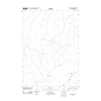
2012 Map of Lightning Ridge
USGS Topo · Published 2012About this map
Lighting Ridge and the broad expanse of Yellow Flats define this pocket of the Wyoming landscape, where water management is central to the high-desert terrain. The network of drainage systems including Shaw Cr, Willow Cr, and the Buffalo Cr feed into several localized catchment areas. Small-scale ranching and land use are evidenced by named landmarks such as Two Tree Reservoir, Yellow Flats Reservoir, and Round Corral Reservoir, which are connected by a sparse grid of rural roads.
Find a feature on this map
21 named features on this map. Tap any name to fly to it.
Don’t see what you’re looking for? This feature index may not catch every label — zoom into the map to look around manually.
Map Details
Editions of this 2012 Lightning Ridge Map
This is the sole edition of this map. No revisions or reprints were ever made.
Other maps of this area

1952 · Battle Mountain
USGS Topo · 1:24,000

1955 · Arminto
USGS Topo · 1:250,000

1958 · Arminto
USGS Topo · 1:250,000

1962 · Arminto
USGS Topo · 1:250,000

1966 · Big Trails
USGS Topo · 1:24,000

1966 · Deadline Draw
USGS Topo · 1:24,000

1966 · Indian Creek
USGS Topo · 1:24,000

1966 · Sand Point
USGS Topo · 1:24,000

1967 · Mahogany Butte
USGS Topo · 1:24,000
1967 · Cornell Gulch
USGS Topo · 1:24,000