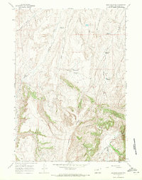
1967 Map of Lightning Ridge
USGS Topo · Published 1971About this map
Lightning Ridge dominates the high ground of this section of Washakie County, where the landscape transitions from steep drainage basins to elevated grazing plateaus. The 1960s range economy is clearly marked by a sophisticated system of water management, featuring named catchments such as Two Tree Reservoir, Corner Reservoir, and the Yellow Flats Reservoir. These features reflect the essential infrastructure required for livestock in the arid Wyoming interior. Along the southeastern edge, the Nowood River cuts through the terrain near the Orchard Landing Strip, indicating the importance of small-scale aviation for remote ranching operations. The presence of numerous named draws, including Telephone Draw and Homestead Draw, suggests a landscape shaped by historical land claims and local communications routes. This survey provides a precise record of the land before modern intensive development, documenting the springs, wells, and Jeep Trails that connected these isolated homesteads.
Find a feature on this map
25 named features on this map. Tap any name to fly to it.
Don’t see what you’re looking for? This feature index may not catch every label — zoom into the map to look around manually.
Map Details
Editions of this 1967 Lightning Ridge Map
This is the sole edition of this map. No revisions or reprints were ever made.
Other maps of this area

1952 · Battle Mountain
USGS Topo · 1:24,000

1955 · Arminto
USGS Topo · 1:250,000

1958 · Arminto
USGS Topo · 1:250,000

1962 · Arminto
USGS Topo · 1:250,000

1966 · Big Trails
USGS Topo · 1:24,000

1966 · Deadline Draw
USGS Topo · 1:24,000

1966 · Indian Creek
USGS Topo · 1:24,000

1966 · Sand Point
USGS Topo · 1:24,000

1967 · Mahogany Butte
USGS Topo · 1:24,000
1967 · Cornell Gulch
USGS Topo · 1:24,000