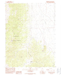
1990 Map of Limestone Peak
USGS Topo · Published 1990About this map
The White Pine Range dominates this late-twentieth-century landscape, providing a detailed view of the high-altitude terrain within the Humboldt National Forest. The map is centered on Limestone Peak, illustrating the transition from the steep western slopes of the range down into the open expanse of Jakes Valley to the east. Water resources in this arid environment are carefully documented, marking essential points such as Butte Spring and the Circle Wash Reservoir. The path of Circle Wash winds through the southern portion of the quadrangle, indicating the natural drainage patterns that define the local geography. This survey captures the region just before the turn of the millennium, reflecting the enduring boundary lines of the R 59 E R 60 E range and T 16 N T 15 N township divisions.
Find a feature on this map
9 named features on this map. Tap any name to fly to it.
Don’t see what you’re looking for? This feature index may not catch every label — zoom into the map to look around manually.
Map Details
Editions of this 1990 Limestone Peak Map
This is the sole edition of this map. No revisions or reprints were ever made.
Other maps of this area

1949 · Treasure Hill
USGS Topo · 1:62,500

1950 · Treasure Hill
USGS Topo · 1:62,500

1951 · Illipah
USGS Topo · 1:62,500

1956 · Ely
USGS Topo · 1:250,000

1959 · Ely
USGS Topo · 1:250,000

1959 · Reipetown
USGS Topo · 1:62,500

1959 · Preston Reservoir
USGS Topo · 1:62,500

1963 · Ely
USGS Topo · 1:250,000

1979 · Mt. Hamilton
USGS Topo · 1:100,000
1990 · Treasure Hill
USGS Topo · 1:24,000