
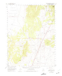
1959 Map of Preston Reservoir
USGS Topo · Published 1961About this map
The high desert landscape of Humboldt National Forest and the Egan Range dominates this late-1950s survey of eastern Nevada. Water management is the primary theme of the arid terrain, visible through the mapping of the Preston Reservoir and Deadman Gulch Reservoir, alongside critical infrastructure like the Preston Seeding Windmill and Jakes Wash Well. The map captures a moment of ranching and land use where every spring and wash is significant, including the southern reaches of Jakes Valley and the Sierra Valley. Transportation is largely restricted to a network of jeep trails and a solitary Landing Strip, reflecting the isolation of this region. Notable landmarks such as Dark Peak and the high point at Rib Hill provide orientation across the network of seasonal drainages like Giroux Wash and Lion Spring Wash.
Find a feature on this map
30 named features on this map. Tap any name to fly to it.
Don’t see what you’re looking for? This feature index may not catch every label — zoom into the map to look around manually.
Map Details
Editions of this 1959 Preston Reservoir Map
2 editions found
Other maps of this area

1949 · Treasure Hill
USGS Topo · 1:62,500

1950 · Treasure Hill
USGS Topo · 1:62,500

1951 · Illipah
USGS Topo · 1:62,500

1952 · Ely
USGS Topo · 1:125,000

1956 · Lund
USGS Topo · 1:250,000

1956 · Ely
USGS Topo · 1:250,000

1957 · Currant Mtn
USGS Topo · 1:62,500

1958 · Ruth
USGS Topo · 1:24,000

1958 · Ely
USGS Topo · 1:62,500

1958 · McGill
USGS Topo · 1:62,500