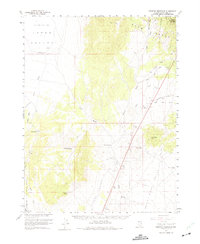
1959 Map of Preston Reservoir
USGS Topo · Published 1975About this map
Jakes Valley and the White River Valley define the arid landscape of this 1950s-era survey, divided by the high peaks of the Egan Range. In this remote corridor of eastern Nevada, water management is the primary driver of development, illustrated by a network of isolated outposts such as Midway Well, Jakes Wash Well, and the Preston Seeding Windmill. The presence of the Preston Reservoir and the Deadman Gulch Reservoir indicates the careful capture of seasonal drainage from the surrounding mountains, while the Humboldt National Forest boundary marks the edge of the protected high country.
Find a feature on this map
28 named features on this map. Tap any name to fly to it.
Don’t see what you’re looking for? This feature index may not catch every label — zoom into the map to look around manually.
Map Details
Editions of this 1959 Preston Reservoir Map
2 editions found

Other maps of this area

1949 · Treasure Hill
USGS Topo · 1:62,500

1950 · Treasure Hill
USGS Topo · 1:62,500

1951 · Illipah
USGS Topo · 1:62,500

1952 · Ely
USGS Topo · 1:125,000

1956 · Lund
USGS Topo · 1:250,000

1956 · Ely
USGS Topo · 1:250,000

1957 · Currant Mtn
USGS Topo · 1:62,500

1958 · Ruth
USGS Topo · 1:24,000

1958 · Ely
USGS Topo · 1:62,500

1958 · McGill
USGS Topo · 1:62,500