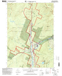
1995 Map of Lincoln
USGS Topo · Published 2000About this map
Lincoln and North Woodstock anchor this 1995 survey of the White Mountains, where the confluence of the East Branch Pemigewasset River and Moosilauke Brook serves as a gateway to the high peaks. The landscape is defined by the intersection of forest preservation and seasonal recreation, featuring the expansive Franconia Notch State Park and the developed slopes of the Loon Mountain Winter Sports Area. Local landmarks like the Covered Bridge and The Flume indicate a long-standing tourism economy centered on the Notch. Education and infrastructure are represented by the centrally located Lin-Wood High School and industrial sites such as the Gravel Pit. Hikers can trace the Appalachian Trail as it traverses the western ridges, passing through the White Mountain National Forest toward summits like Kinsman Mtn South Peak.
Find a feature on this map
90 named features on this map. Tap any name to fly to it.
Don’t see what you’re looking for? This feature index may not catch every label — zoom into the map to look around manually.
Map Details
Editions of this 1995 Lincoln Map
This is the sole edition of this map. No revisions or reprints were ever made.
Other maps of this area

1928 · Plymouth
USGS Topo · 1:62,500

1928 · Rumney
USGS Topo · 1:62,500

1929 · Moosilauke
USGS Topo · 1:62,500

1929 · Franconia
USGS Topo · 1:62,500

1931 · Plymouth
USGS Topo · 1:62,500

1932 · Franconia
USGS Topo · 1:62,500

1932 · Rumney
USGS Topo · 1:62,500

1932 · Moosilauke
USGS Topo · 1:62,500

1949 · Portland
USGS Topo · 1:250,000

1950 · Lewiston
USGS Topo · 1:250,000