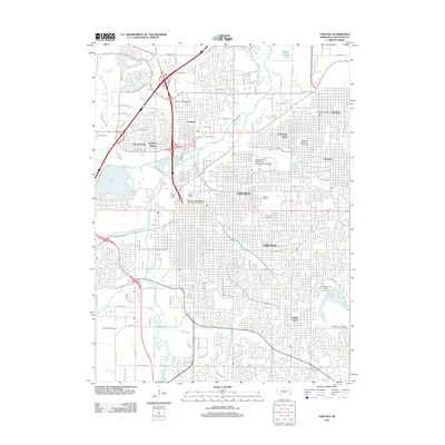
2011 Map of Lincoln
USGS Topo · Published 2011About this map
The state capital of Lincoln serves as the focal point of this 2011 survey, displaying a complex urban environment shaped by education, government, and its unique drainage network. The landscape is defined by the convergence of several waterways, including Salt Creek, Antelope Creek, and Deadmans Run, which thread through established residential neighborhoods like Belmont and Bethany. Significant institutional footprints are visible throughout the city, notably the University of Nebraska - Lincoln (City Campus) and Nebraska Wesleyan University in the University Place district. Local history is deeply etched into the city’s geography via a series of large, historic burial grounds, ranging from Wyuka Cemetery in the east to Yankee Hill Cemetery in the southwest. The presence of the Havelock Post Office and the Lincoln Post Office underscores the civic infrastructure of this modern era, while landmarks like Mueller Tower provide specific vertical points of interest within the university grounds.
Find a feature on this map
68 named features on this map. Tap any name to fly to it.
Don’t see what you’re looking for? This feature index may not catch every label — zoom into the map to look around manually.
Map Details
Editions of this 2011 Lincoln Map
This is the sole edition of this map. No revisions or reprints were ever made.
Other maps of this area

1897 · Lincoln
USGS Topo · 1:125,000

1955 · Lincoln
USGS Topo · 1:250,000

1957 · Lincoln
USGS Topo · 1:250,000

1958 · Lincoln
USGS Topo · 1:250,000

1964 · Waverly
USGS Topo · 1:24,000

1964 · Denton
USGS Topo · 1:24,000

1964 · Roca
USGS Topo · 1:24,000

1964 · Davey
USGS Topo · 1:24,000

1964 · Walton
USGS Topo · 1:24,000
1964 · Emerald
USGS Topo · 1:24,000