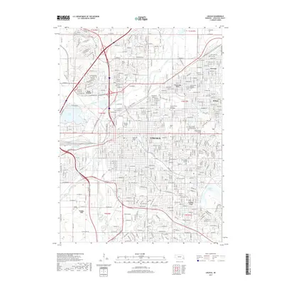
2017 Map of Lincoln
USGS Topo · Published 2017About this map
Lincoln serves as the focal point of this 2017 survey, showcasing a dense urban grid and its surrounding neighborhoods such as University Place, Bethany, and Havelock. The map detail captures the capital city's academic and industrial character, highlighting the sprawling grounds of the University of Nebraska - Lincoln and its East Campus alongside institutions like Nebraska Wesleyan Univ and Union College. Significant transportation corridors are evident through the BNSF Railway lines and major thoroughfares like O St and Capitol Pkwy W, which navigate the city's topography shaped by Salt Creek and its tributaries. Local history is anchored by established landmarks including the expansive Wyuka Cem and the College View district, while recreational features like Holmes Lake and Oak Lake provide essential green space within the suburban landscape of Yankee Hill and West Lincoln.
Find a feature on this map
102 named features on this map. Tap any name to fly to it.
Don’t see what you’re looking for? This feature index may not catch every label — zoom into the map to look around manually.
Map Details
Editions of this 2017 Lincoln Map
This is the sole edition of this map. No revisions or reprints were ever made.
Other maps of this area

1897 · Lincoln
USGS Topo · 1:125,000

1955 · Lincoln
USGS Topo · 1:250,000

1957 · Lincoln
USGS Topo · 1:250,000

1958 · Lincoln
USGS Topo · 1:250,000

1964 · Waverly
USGS Topo · 1:24,000

1964 · Denton
USGS Topo · 1:24,000

1964 · Roca
USGS Topo · 1:24,000

1964 · Davey
USGS Topo · 1:24,000

1964 · Walton
USGS Topo · 1:24,000
1964 · Emerald
USGS Topo · 1:24,000