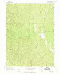
1966 Map of Lincoln Ridge
USGS Topo · Published 1969About this map
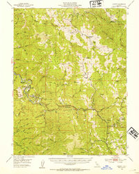
Lincoln Ridge and Packard Ridge dominate this mid-century look at the remote northern California interior, where the South Fork Eel River winds through narrow valleys. The landscape is defined by its drainage basins, with numerous watercourses like Hollow Tree Creek, Wages Creek, and Jack of Hearts Creek cutting through the steep terrain. The presence of Wilderness Lodge in the northeast and agricultural clearings such as Baptiste Orchard and Strauss Orchard indicate a mix of seasonal recreation and small-scale cultivation nestled within the timberlands.
Find a feature on this map
46 named features on this map. Tap any name to fly to it.
Don’t see what you’re looking for? This feature index may not catch every label — zoom into the map to look around manually.
Map Details
Editions of this 1966 Lincoln Ridge Map
2 editions found

Other maps of this area

1920 · Cummings
USGS Topo · 1:62,500

1921 · Westport
USGS Topo · 1:62,500

1921 · Branscomb
USGS Topo · 1:62,500
1950 · Piercy
USGS Topo · 1:62,500
1950 · Cape Vizcaino
USGS Topo · 1:62,500

1951 · Cape Vizcaino
USGS Topo · 1:62,500
1951 · Branscomb
USGS Topo · 1:62,500
1952 · Leggett
USGS Topo · 1:62,500

1957 · Ukiah
USGS Topo · 1:250,000

1960 · Ukiah
USGS Topo · 1:250,000