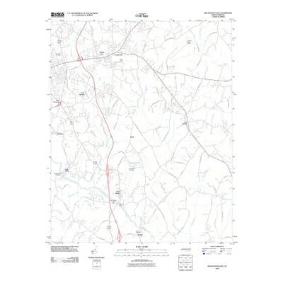
2010 Map of Lincolnton East
USGS Topo · Published 2010About this map
The South Fork Catawba River winds through the heart of Lincoln County, defining the industrial and agricultural landscape near High Shoals. This 2010 survey reflects a region where traditional settlements like Iron Station and Boger City have evolved alongside modern transportation hubs such as the Lincoln County Airport. The persistence of early place names and railroad-related markers, including Miller Siding, suggests a transition from a rail-reliant economy to one of rural-suburban growth.
Find a feature on this map
86 named features on this map. Tap any name to fly to it.
Don’t see what you’re looking for? This feature index may not catch every label — zoom into the map to look around manually.
Map Details
Editions of this 2010 Lincolnton East Map
This is the sole edition of this map. No revisions or reprints were ever made.
Other maps of this area

1895 · Hickory
USGS Topo · 1:125,000

1909 · Lincolnton
USGS Topo · 1:62,500

1911 · Lincolnton
USGS Topo · 1:62,500

1914 · Gastonia
USGS Topo · 1:48,000

1916 · Gastonia
USGS Topo · 1:62,500

1953 · Charlotte
USGS Topo · 1:250,000

1954 · Charlotte
USGS Topo · 1:250,000

1960 · Charlotte
USGS Topo · 1:250,000

1962 · Charlotte
USGS Topo · 1:250,000
1970 · Mount Holly
USGS Topo · 1:24,000