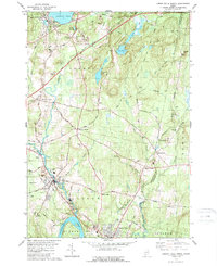
1979 Map of Lisbon Falls North
USGS Topo · Published 1989About this map
The Androscoggin River and its tributary, the Sabattus River, define the industrial and agricultural corridors of this southern Maine landscape during the late 1970s. The village of Lisbon Falls anchors the southern reaches of the map, showing a concentrated settlement pattern near the river bends, while the Maine Central railroad tracks parallel the water, tracing the historical path of the region's mill-driven economy. Further north, the expansive Sabattus Pond feeds the river system, surrounded by a network of rural crossroads like Drinkwater Corner and Webster Corner.
Find a feature on this map
63 named features on this map. Tap any name to fly to it.
Don’t see what you’re looking for? This feature index may not catch every label — zoom into the map to look around manually.
Map Details
Editions of this 1979 Lisbon Falls North Map
3 editions found
Other maps of this area

1892 · Gardiner
USGS Topo · 1:62,500

1892 · Freeport
USGS Topo · 1:62,500

1894 · Bath
USGS Topo · 1:62,500

1908 · Lewiston
USGS Topo · 1:62,500

1920 · Bath
USGS Topo · 1:62,500

1941 · Freeport
USGS Topo · 1:62,500

1942 · Lewiston
USGS Topo · 1:62,500

1943 · Gardiner
USGS Topo · 1:62,500

1944 · Freeport
USGS Topo · 1:62,500

1945 · Bath
USGS Topo · 1:62,500