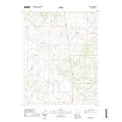
2023 Map of Lisbon Gap
USGS Topo · Published 2023About this map
Lisbon Gap serves as a prominent geographic landmark in this high-desert landscape along the Utah and Colorado border. The terrain is defined by a series of elevated flats and deeply incised drainages, including Island Mesa, Mid Mesa, and Ray Mesa. These mesas are separated by an intricate network of seasonal waterways such as East Coyote Wash, Greasewood Canyon, and Bullhorn Wash.
Find a feature on this map
29 named features on this map. Tap any name to fly to it.
Don’t see what you’re looking for? This feature index may not catch every label — zoom into the map to look around manually.
Map Details
Editions of this 2023 Lisbon Gap Map
This is the sole edition of this map. No revisions or reprints were ever made.
Other maps of this area

1885 · La Sal
USGS Topo · 1:250,000

1916 · Paradox Valley
USGS Topo · 1:125,000

1922 · Paradox Valley
USGS Topo · 1:125,000

1948 · Horse Range Mesa
USGS Topo · 1:24,000

1948 · Paradox
USGS Topo · 1:24,000

1949 · Paradox
USGS Topo · 1:24,000
1949 · Anderson Mesa
USGS Topo · 1:24,000

1950 · Horse Range Mesa
USGS Topo · 1:24,000
1950 · Anderson Mesa
USGS Topo · 1:24,000

1954 · Mt Peale 1 SE
USGS Topo · 1:24,000