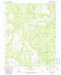
1986 Map of Lisbon Gap
USGS Topo · Published 1986About this map
Island Mesa and Middle Mesa define the high ground of this high-desert landscape along the Utah-Colorado border, where the terrain breaks sharply into the Lower Lisbon Valley. This mid-1980s survey captures a geography defined by its drainage systems and mineral exploration, with several prospects and a mine located east of the state line. The namesake Lisbon Gap serves as a critical passage through the uplift, while named drainages like Snyder Water Canyon and Greasewood Canyon illustrate the erosional patterns of the Colorado Plateau. The map also records the jurisdictional intersection of San Juan County, Utah, with Montrose and San Miguel Counties in Colorado. For those tracing the history of resource extraction, the presence of various drill holes and survey points near Horsethief Point provides a record of late-20th-century industrial activity in this sparsely settled region.
Find a feature on this map
20 named features on this map. Tap any name to fly to it.
Don’t see what you’re looking for? This feature index may not catch every label — zoom into the map to look around manually.
Map Details
Editions of this 1986 Lisbon Gap Map
This is the sole edition of this map. No revisions or reprints were ever made.
Other maps of this area

1885 · La Sal
USGS Topo · 1:250,000

1916 · Paradox Valley
USGS Topo · 1:125,000

1922 · Paradox Valley
USGS Topo · 1:125,000

1948 · Horse Range Mesa
USGS Topo · 1:24,000

1948 · Paradox
USGS Topo · 1:24,000

1949 · Paradox
USGS Topo · 1:24,000
1949 · Anderson Mesa
USGS Topo · 1:24,000

1950 · Horse Range Mesa
USGS Topo · 1:24,000
1950 · Anderson Mesa
USGS Topo · 1:24,000

1954 · Mt Peale 1 SE
USGS Topo · 1:24,000