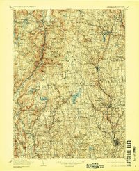
1904 Map of Litchfield
USGS Topo · Published 1923About this map
The Housatonic River carves a path through this section of the Litchfield Hills, defining the industrial and transit corridor for the N.Y. N.H. & H. R.R. at the turn of the century. This 1904 survey reveals a landscape balanced between concentrated manufacturing hubs and high-elevation farming communities. The iron heritage of the region is evident at Ore Hill and Red Rocks, while the numerous river crossings like Cornwall Bridge and Swift's Bridge underscore the connectivity required by the era's commerce.
Find a feature on this map
238 named features on this map. Tap any name to fly to it.
Don’t see what you’re looking for? This feature index may not catch every label — zoom into the map to look around manually.
Map Details
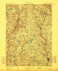
Editions of this 1904 Litchfield Map
3 editions found

Other maps of this area

1885 · Sheffield
USGS Topo · 1:62,500

1887 · Granville
USGS Topo · 1:62,500

1888 · Sheffield
USGS Topo · 1:62,500

1888 · Sandisfield
USGS Topo · 1:62,500

1889 · Derby
USGS Topo · 1:62,500

1889 · Granville
USGS Topo · 1:62,500

1891 · Sheffield
USGS Topo · 1:62,500

1891 · Derby
USGS Topo · 1:62,500

1892 · Winsted
USGS Topo · 1:62,500

1892 · New Haven
USGS Topo · 1:62,500