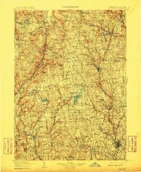
1904 Map of Litchfield
USGS Topo · Published 1910About this map
Litchfield and the surrounding highlands of northwestern Connecticut are defined by the winding course of the Housatonic River and a dense network of early industrial and agricultural settlements. At this turn-of-the-century moment, the region's iron heritage remains visible through landmarks like Kent Furnace, while the expansion of the railroad is marked by nodes such as Limerock Sta. and Washington Depot. The map reveals a landscape of high-elevation water bodies, from the sprawling Bantam Lake to the smaller Wononskopomuc Lake near Lakeville, which supported local economies and early recreation. Many of the small hamlets shown, including Cornwall Hollow and Amesville, represent the decentralized settlement patterns common before mid-century urbanization consolidated populations into larger borough centers. Moving south toward New Milford and Woodbury, the terrain transitions into the more open valleys that define the Litchfield Hills' southern reach.
Find a feature on this map
205 named features on this map. Tap any name to fly to it.
Don’t see what you’re looking for? This feature index may not catch every label — zoom into the map to look around manually.
Map Details
Editions of this 1904 Litchfield Map
3 editions found

Other maps of this area

1885 · Sheffield
USGS Topo · 1:62,500

1887 · Granville
USGS Topo · 1:62,500

1888 · Sheffield
USGS Topo · 1:62,500

1888 · Sandisfield
USGS Topo · 1:62,500

1889 · Derby
USGS Topo · 1:62,500

1889 · Granville
USGS Topo · 1:62,500

1891 · Sheffield
USGS Topo · 1:62,500

1891 · Derby
USGS Topo · 1:62,500

1892 · Winsted
USGS Topo · 1:62,500

1892 · New Haven
USGS Topo · 1:62,500