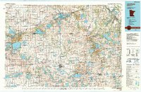
1986 Map of Litchfield
USGS Topo · Published 1990About this map
Litchfield serves as a central hub for this mid-1980s landscape, where the agricultural plains of Central Minnesota are punctuated by an immense density of glacial lakes and managed wildlife areas. The corridor of US Highway 12 and the Burlington Northern Railroad links established grain and trade centers like Dassel, Cokato, and Darwin. The map reveals a highly structured conservation network, with dozens of sites such as the Zion State Wildlife Management Area and Burbank State Wildlife Management Area preserving the prairie-pothole ecology between working farms.
Find a feature on this map
204 named features on this map. Tap any name to fly to it.
Don’t see what you’re looking for? This feature index may not catch every label — zoom into the map to look around manually.
Map Details
Editions of this 1986 Litchfield Map
2 editions found
Other maps of this area

1950 · St. Cloud
USGS Topo · 1:62,500

1951 · Annandale
USGS Topo · 1:62,500

1953 · Saint Paul
USGS Topo · 1:250,000

1953 · New Ulm
USGS Topo · 1:250,000

1953 · Saint Cloud
USGS Topo · 1:250,000

1953 · Stillwater
USGS Topo · 1:250,000

1955 · Stillwater
USGS Topo · 1:250,000

1956 · Atwater
USGS Topo · 1:62,500

1957 · Saint Cloud
USGS Topo · 1:250,000

1957 · New Ulm
USGS Topo · 1:250,000