
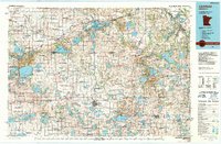
1986 Map of Litchfield
USGS Topo · Published 1986About this map
Glacial lakes and wetlands dominate this mid-1980s landscape across Central Minnesota, defined by a dense network of wildlife management areas and waterfowl production sites. The North Fork Crow River and the Sauk River wind through a region where agriculture and conservation coexist. Significant water bodies like Green Lake, Diamond Lake, and Lake Elizabeth anchor the landscape, while the Burlington Northern railroad corridor provides a vital industrial link between the settlements of Litchfield and Paynesville. Local history is preserved in the numerous named townships such as Danielson and Kingston, and the placement of country churches like St Nicholas and St Augusta. The map also details early aviation and communications infrastructure, including the Municipal Airport near the county seat and various scattered Radio Towers.
Find a feature on this map
249 named features on this map. Tap any name to fly to it.
Don’t see what you’re looking for? This feature index may not catch every label — zoom into the map to look around manually.
Map Details
Editions of this 1986 Litchfield Map
2 editions found
Other maps of this area
1950 · St. Cloud
USGS Topo · 1:62,500

1951 · Annandale
USGS Topo · 1:62,500

1953 · Saint Paul
USGS Topo · 1:250,000

1953 · New Ulm
USGS Topo · 1:250,000

1953 · Saint Cloud
USGS Topo · 1:250,000

1953 · Stillwater
USGS Topo · 1:250,000

1955 · Stillwater
USGS Topo · 1:250,000
1956 · Atwater
USGS Topo · 1:62,500

1957 · Saint Cloud
USGS Topo · 1:250,000

1957 · New Ulm
USGS Topo · 1:250,000