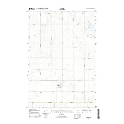
2014 Map of Litchville
USGS Topo · Published 2014About this map
Litchville serves as the central hub of this prairie landscape, where the grid of rural roads meets the diagonal path of N P Ave. The town’s layout, featuring streets like 5th St and 1st Ave, reflects the organized settlement patterns typical of the North Dakota plains. Beyond the town limits, the geography is defined by the subtle drainage of Spring Cr and Bear Cr, which wind through a landscape dotted with numerous small potholes and depressions. For those researching local heritage, the map identifies several key burial sites, including the Swedish Cem to the southeast and the Catholic grounds of Saint Anns Cem and Saint Thomas Cem to the west. The boundary between Barnes Co and LaMoure Co at the southern edge of the sheet provides a fixed point for local administrative and land history.
Find a feature on this map
34 named features on this map. Tap any name to fly to it.
Don’t see what you’re looking for? This feature index may not catch every label — zoom into the map to look around manually.
Map Details
Editions of this 2014 Litchville Map
This is the sole edition of this map. No revisions or reprints were ever made.
Other maps of this area

1897 · Eckelson
USGS Topo · 1:125,000

1953 · Jamestown
USGS Topo · 1:250,000

1956 · Jamestown
USGS Topo · 1:250,000

1970 · Litchville
USGS Topo · 1:24,000
1970 · Hastings
USGS Topo · 1:24,000
1970 · Litchville SW
USGS Topo · 1:24,000
1970 · Litchville SE
USGS Topo · 1:24,000
1970 · Moon Lake
USGS Topo · 1:24,000

1970 · Marion NE
USGS Topo · 1:24,000
1970 · Sanborn SE
USGS Topo · 1:24,000