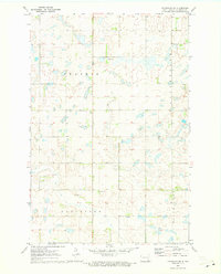
1970 Map of Litchville SW
USGS Topo · Published 1973About this map
Glacial potholes and prairie wetlands define this rural portion of LaMoure County during the early 1970s. The landscape is dominated by the sprawling Prairie, dotted with numerous small water bodies and drainage basins characteristic of the region. Local community life is anchored by the Griswold Ch and the nearby Griswold Cem, providing essential points of interest for those researching the genealogy of this North Dakota township. To the north, the Lutheran Cem sits amidst the section lines, while the southern reaches include the named areas of Gladstone and Black. Several Gravel Pit operations are visible, indicating the localized resource extraction that supported the area's road network and infrastructure during this period of the late twentieth century.
Find a feature on this map
9 named features on this map. Tap any name to fly to it.
Don’t see what you’re looking for? This feature index may not catch every label — zoom into the map to look around manually.
Map Details
Editions of this 1970 Litchville SW Map
This is the sole edition of this map. No revisions or reprints were ever made.
Other maps of this area

1894 · La Moure
USGS Topo · 1:62,500

1895 · Lamoure
USGS Topo · 1:125,000

1897 · Eckelson
USGS Topo · 1:125,000

1918 · La Moure
USGS Topo · 1:125,000

1952 · Grand Rapids
USGS Topo · 1:24,000

1953 · Jamestown
USGS Topo · 1:250,000

1956 · Jamestown
USGS Topo · 1:250,000

1970 · Litchville
USGS Topo · 1:24,000
1970 · Hastings
USGS Topo · 1:24,000
1970 · Verona NW
USGS Topo · 1:24,000
Featured Places
- Litchville Township, ND
- Black Loam Township, ND
- Gladstone Township, ND
- Prairie Township, ND
- LaMoure County, ND