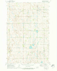
1970 Map of Verona NW
USGS Topo · Published 1973About this map
Glacial prairie potholes and scattered wetlands define this section of LaMoure County, captured here as it appeared in the late 1960s. The landscape is a matrix of agricultural boundaries including Gladstone, Black Loam, Pearl Lake, and Greenville. Human settlement is sparse, centered on the crossroads at Benson Corner in the northern portion of the quadrangle. A significant section of the northeastern corner is dedicated to a National Wildlife Management Area, highlighting the region's importance for migratory waterfowl and native habitat preservation. Small-scale industrial activity is evident through several Gravel Pits located near the section lines, suggesting the local importance of aggregate mining for road construction in this rural terrain.
Find a feature on this map
8 named features on this map. Tap any name to fly to it.
Don’t see what you’re looking for? This feature index may not catch every label — zoom into the map to look around manually.
Map Details
Editions of this 1970 Verona NW Map
This is the sole edition of this map. No revisions or reprints were ever made.
Other maps of this area

1894 · La Moure
USGS Topo · 1:62,500

1895 · Lamoure
USGS Topo · 1:125,000

1897 · Eckelson
USGS Topo · 1:125,000

1918 · La Moure
USGS Topo · 1:125,000

1952 · Grand Rapids
USGS Topo · 1:24,000

1952 · Independence
USGS Topo · 1:24,000

1953 · Jamestown
USGS Topo · 1:250,000
1955 · La Moure
USGS Topo · 1:24,000

1956 · Jamestown
USGS Topo · 1:250,000
1970 · Litchville SW
USGS Topo · 1:24,000
Featured Places
- Black Loam Township, ND
- Gladstone Township, ND
- Benson Corner, ND
- Pearl Lake Township, ND
- Greenville Township, ND