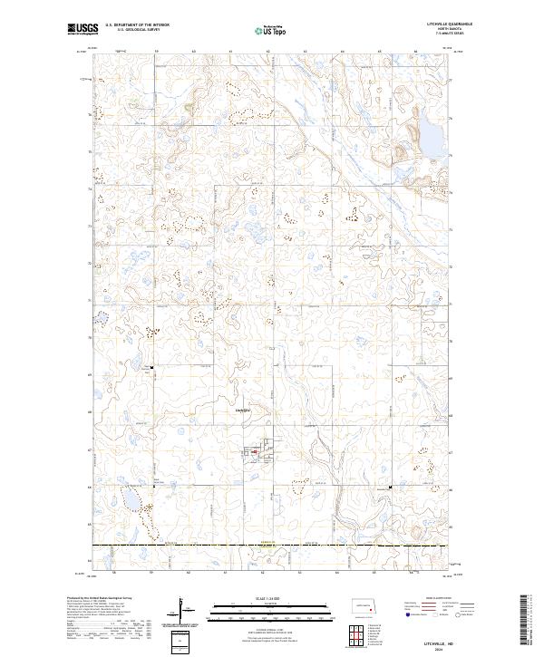
2024 Map of Litchville
USGS Topo · Published 2024About this map
Litchville serves as the central hub of this Barnes County landscape, where the town’s grid is clearly defined amidst a network of section-line roads like Co Hwy 11. The topography is marked by glacial potholes and the meandering paths of Spring Creek and Bear Creek. For those tracing local heritage, the map identifies significant burial sites including Saint Thomas Cem, Saint Anns Cem, and the Swedish Cem, which reflect the area's early settlement patterns. To the northeast, the Barnes County Waterfowl Production Area covers several sections of land, highlighting the region's focus on conservation and natural prairie habitat. The southern edge of the sheet marks the transition from Barnes Co into LaMoure Co, illustrating the precise administrative boundaries of these North Dakota townships.
Find a feature on this map
32 named features on this map. Tap any name to fly to it.
Don’t see what you’re looking for? This feature index may not catch every label — zoom into the map to look around manually.
Map Details
Editions of this 2024 Litchville Map
This is the sole edition of this map. No revisions or reprints were ever made.
Other maps of this area

1897 · Eckelson
USGS Topo · 1:125,000

1953 · Jamestown
USGS Topo · 1:250,000

1956 · Jamestown
USGS Topo · 1:250,000

1970 · Litchville
USGS Topo · 1:24,000
1970 · Hastings
USGS Topo · 1:24,000
1970 · Litchville SW
USGS Topo · 1:24,000
1970 · Litchville SE
USGS Topo · 1:24,000
1970 · Moon Lake
USGS Topo · 1:24,000

1970 · Marion NE
USGS Topo · 1:24,000
1970 · Sanborn SE
USGS Topo · 1:24,000