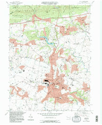
1995 Map of Lititz
USGS Topo · Published 1996About this map
Lititz serves as the focal point of this mid-1990s survey, surrounded by the agricultural and industrial landscapes of Lancaster County. The town is marked by institutional landmarks including the Linden Hall Sch, Warwick High Sch, and a concentration of civic infrastructure near N Cedar St and Front St. North of the borough, the Furnace Hills and State Game Lands No 156 provide a wooded backdrop to small villages like Brickerville and Poplar Grove. The map records a dense network of country houses, old cemeteries, and numerous local congregations such as St Johns Ch and Old Zion Ch. Waterways like Hammer Creek feed the Speedwell Forge Lake, where the Speedwell Forge Dam and local boat ramps indicate the area's recreational use alongside traditional farming and quarrying activities.
Find a feature on this map
91 named features on this map. Tap any name to fly to it.
Don’t see what you’re looking for? This feature index may not catch every label — zoom into the map to look around manually.
Map Details
Editions of this 1995 Lititz Map
This is the sole edition of this map. No revisions or reprints were ever made.
Other maps of this area

1891 · Lebanon
USGS Topo · 1:62,500

1893 · Lebanon
USGS Topo · 1:62,500

1899 · Lebanon
USGS Topo · 1:62,500

1902 · Wernersville
USGS Topo · 1:62,500

1902 · Lancaster
USGS Topo · 1:62,500

1904 · Lancaster
USGS Topo · 1:62,500

1906 · New Holland
USGS Topo · 1:62,500

1908 · New Holland
USGS Topo · 1:62,500

1941 · New Holland
USGS Topo · 1:62,500

1943 · Lancaster
USGS Topo · 1:62,500