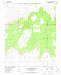
1980 Map of Little Creek Mountain
USGS Topo · Published 1981About this map
Little Creek Mountain dominates the landscape of Washington County, Utah, in this 1980 survey, characterized by its prominent high plateaus and the transition to the Little Plain. This topographic study, based on 1973 aerial photography, details a landscape defined by dramatic geological transitions like Canaan Gap and the northern reach of Gooseberry Mesa. Resource extraction and land management are evident through the presence of several Cinderpits near Gray Knoll and a Radio Tower on the central heights. Isolated water sources such as Gould Spring and the drainage of Gould Wash highlight the arid environment. A distinctive local clearing, Abs Clearing, appears on the mountain's upper reaches, providing a specific reference point for researchers tracing the history of local land use and seasonal activity in the high desert of the Arizona-Utah border region.
Find a feature on this map
16 named features on this map. Tap any name to fly to it.
Don’t see what you’re looking for? This feature index may not catch every label — zoom into the map to look around manually.
Map Details
Editions of this 1980 Little Creek Mountain Map
This is the sole edition of this map. No revisions or reprints were ever made.
Other maps of this area

1885 · St. George
USGS Topo · 1:250,000

1886 · Mt. Trumbull
USGS Topo · 1:250,000

1891 · St. George
USGS Topo · 1:250,000

1892 · Mt. Trumbull
USGS Topo · 1:250,000

1953 · Cedar City
USGS Topo · 1:250,000

1953 · Grand Canyon
USGS Topo · 1:250,000

1954 · La Verkin 4 SE
USGS Topo · 1:24,000

1954 · La Verkin 4 NW
USGS Topo · 1:24,000

1954 · La Verkin 4 SW
USGS Topo · 1:24,000

1954 · Hurricane Cliffs 2 NE
USGS Topo · 1:24,000