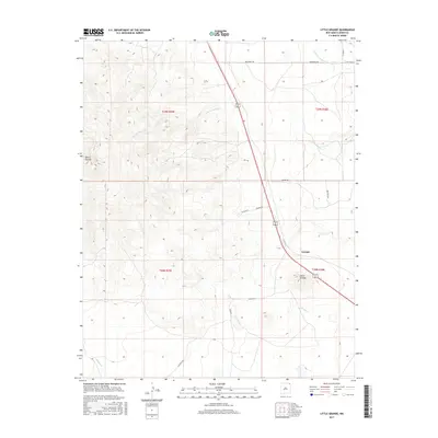
2017 Map of Little Grande
USGS Topo · Published 2017About this map
Sierra Grande dominates the western edge of this Union County landscape, where the high plains meet volcanic terrain. This 2017 survey details a sparsely populated ranching region defined by its drainage basins, including the headwaters of Seneca Cr and the northern and southern branches of N Br Corrumpa Cr and S Br Corrumpa Cr. The small settlements of Grande and Little Grande serve as focal points along the highway corridor, surrounded by a network of rural routes that carry the names of local families, such as Weatherly Rd, Gallegos Rd, Severo Rd, and Martinez Rd. The map illustrates the enduring Public Land Survey System (PLSS) grid, showing how township and range lines have shaped property boundaries and road placements across this arid northeast New Mexico territory.
Find a feature on this map
19 named features on this map. Tap any name to fly to it.
Don’t see what you’re looking for? This feature index may not catch every label — zoom into the map to look around manually.
Map Details
Editions of this 2017 Little Grande Map
This is the sole edition of this map. No revisions or reprints were ever made.
Other maps of this area

1954 · Dalhart
USGS Topo · 1:250,000

1958 · Dalhart
USGS Topo · 1:250,000

1962 · Dalhart
USGS Topo · 1:250,000

1972 · Little Grande
USGS Topo · 1:24,000

1972 · Cross L Ranch SW
USGS Topo · 1:24,000
1972 · Des Moines
USGS Topo · 1:24,000

1972 · Capulin
USGS Topo · 1:24,000
1972 · Folsom
USGS Topo · 1:24,000

1972 · Malpie Mountain
USGS Topo · 1:24,000

1972 · Cow Mountain
USGS Topo · 1:24,000