
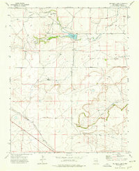
1972 Map of Cow Mountain
USGS Topo · Published 1976About this map
Santa Fe Trail (Cimarron Cutoff) crosses the southern portion of this Union County landscape, marking a historic artery of Western migration and commerce. In this high plains environment during the early 1970s, water management is the primary evidence of human activity and settlement. Numerous named landmarks such as Sintas Windmill, Bryson Windmill, and Marsellino Windmill are scattered across the terrain, serving as essential water sources for the cattle ranching operations that define the area's economy. The topography is dominated by the prominent elevation of Cow Mountain in the northeast, while the drainage of Gallegos Creek carves a path through the center. A small, isolated Cem (cemetery) located near the creek provides a poignant genealogical anchor for the families who worked these expansive ranch lands, where even small features like the Junk Windmill or Fire Windmill were important enough to be specifically recorded by surveyors.
Find a feature on this map
14 named features on this map. Tap any name to fly to it.
Don’t see what you’re looking for? This feature index may not catch every label — zoom into the map to look around manually.
Map Details
Editions of this 1972 Cow Mountain Map
This is the sole edition of this map. No revisions or reprints were ever made.
Other maps of this area

1954 · Dalhart
USGS Topo · 1:250,000

1958 · Dalhart
USGS Topo · 1:250,000

1962 · Dalhart
USGS Topo · 1:250,000

1972 · Little Grande
USGS Topo · 1:24,000

1972 · Capulin
USGS Topo · 1:24,000

1972 · Malpie Mountain
USGS Topo · 1:24,000
1973 · Wetherly Lake
USGS Topo · 1:24,000

1973 · Gladstone NW
USGS Topo · 1:24,000

1973 · Grenville SW
USGS Topo · 1:24,000

1973 · Tripod Mountain
USGS Topo · 1:24,000