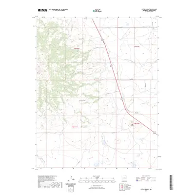
2023 Map of Little Grande
USGS Topo · Published 2023About this map
Sierra Grande dominates this corner of Union County, New Mexico, rising above the high plains and defining the local drainage patterns. The terrain transitions from the volcanic slopes of the mountain to the winding watercourses of the South Branch Corrumpa Creek and North Branch Corrumpa Creek. Small ranching settlements like Grande and Little Grande are situated near the highway corridor, while Gallegos and Gallegos Creek mark the southern portion of the sheet. The map reveals a network of local thoroughfares named for area families and landmarks, such as Weatherly Rd, Severo Rd, and Martinez Rd, which provide access to the remote township sections of T28N and T29N. This landscape is a classic example of New Mexico's northeastern ranching country, where seasonal creeks like Seneca Creek provide critical water for the semi-arid environment.
Find a feature on this map
21 named features on this map. Tap any name to fly to it.
Don’t see what you’re looking for? This feature index may not catch every label — zoom into the map to look around manually.
Map Details
Editions of this 2023 Little Grande Map
This is the sole edition of this map. No revisions or reprints were ever made.
Other maps of this area

1954 · Dalhart
USGS Topo · 1:250,000

1958 · Dalhart
USGS Topo · 1:250,000

1962 · Dalhart
USGS Topo · 1:250,000

1972 · Little Grande
USGS Topo · 1:24,000

1972 · Cross L Ranch SW
USGS Topo · 1:24,000
1972 · Des Moines
USGS Topo · 1:24,000

1972 · Capulin
USGS Topo · 1:24,000
1972 · Folsom
USGS Topo · 1:24,000

1972 · Malpie Mountain
USGS Topo · 1:24,000

1972 · Cow Mountain
USGS Topo · 1:24,000