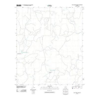
2010 Map of Little Grape Creek
USGS Topo · Published 2010About this map
Little Grape Creek and its larger counterpart, Grape Creek, define the drainage patterns of this central Texas landscape, where land management is anchored by federal water projects. The presence of the Soil Conservation Service Site 1 Reservoir and Soil Conservation Service Site 2 Reservoir, along with their respective structures Soil Conservation Service Site 1 Dam and Soil Conservation Service Site 2 Dam, illustrates a 20th-century approach to flood control and soil stabilization.
Find a feature on this map
16 named features on this map. Tap any name to fly to it.
Don’t see what you’re looking for? This feature index may not catch every label — zoom into the map to look around manually.
Map Details
Editions of this 2010 Little Grape Creek Map
This is the sole edition of this map. No revisions or reprints were ever made.
Other maps of this area

1892 · Ballinger
USGS Topo · 1:125,000

1925 · Ballinger 3-d
USGS Topo · 1:48,000

1925 · Ballinger 4-c
USGS Topo · 1:48,000

1932 · Voss
USGS Topo · 1:62,500

1932 · Paint Rock
USGS Topo · 1:62,500

1954 · Brownwood
USGS Topo · 1:250,000

1967 · Talpa
USGS Topo · 1:24,000
1967 · Concho
USGS Topo · 1:24,000
1967 · Little Grape Creek
USGS Topo · 1:24,000
1967 · Voss
USGS Topo · 1:24,000