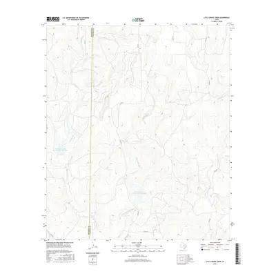
2016 Map of Little Grape Creek
USGS Topo · Published 2016About this map
The Runnels Co and Coleman Co boundary divides this landscape, where the meandering course of Little Grape Creek defines much of the central terrain. This area of West Texas is characterized by its drainage network, featuring tributaries like Wheeler Br and Spring Br that feed into the larger creek systems. Man-made interventions in the natural hydrology are prominent, with the Soil Conservation Service Site 1 Reservoir and Soil Conservation Service Site 2 Reservoir capturing runoff to manage the watershed. These structures indicate a land-use pattern focused on water conservation and flood control in an environment where moisture is a critical resource. A network of rural county routes, including Co RD 374 and Co RD 467, provides access through the private ranch lands and rolling hills that surround Grape Cr and Elm Cr.
Find a feature on this map
16 named features on this map. Tap any name to fly to it.
Don’t see what you’re looking for? This feature index may not catch every label — zoom into the map to look around manually.
Map Details
Editions of this 2016 Little Grape Creek Map
This is the sole edition of this map. No revisions or reprints were ever made.
Other maps of this area

1892 · Ballinger
USGS Topo · 1:125,000

1925 · Ballinger 3-d
USGS Topo · 1:48,000

1925 · Ballinger 4-c
USGS Topo · 1:48,000

1932 · Voss
USGS Topo · 1:62,500

1932 · Paint Rock
USGS Topo · 1:62,500

1954 · Brownwood
USGS Topo · 1:250,000

1967 · Talpa
USGS Topo · 1:24,000
1967 · Concho
USGS Topo · 1:24,000
1967 · Little Grape Creek
USGS Topo · 1:24,000
1967 · Voss
USGS Topo · 1:24,000