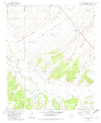
1982 Map of Little Milky Wash
USGS Topo · Published 1983About this map
Potter Mesa dominates the eastern half of this arid landscape, where the seasonal drainage network of Little Milky Wash and Goat Ranch Draw carves through the high desert. The area is characterized by scattered water management features, including livestock tanks like Purple Hill Tank, Thompson Tank, and Middle Tank, which supported ranching operations in this corner of the Colorado Plateau. A notable archaeological site labeled simply as Ruins is situated near the center of the sheet, indicating long-standing human presence in the wash country.
Find a feature on this map
25 named features on this map. Tap any name to fly to it.
Don’t see what you’re looking for? This feature index may not catch every label — zoom into the map to look around manually.
Map Details
Editions of this 1982 Little Milky Wash Map
This is the sole edition of this map. No revisions or reprints were ever made.
Other maps of this area

1886 · St Johns
USGS Topo · 1:250,000

1892 · St Johns
USGS Topo · 1:250,000

1912 · Petrified Forest
USGS Topo · 1:62,500

1954 · Saint Johns
USGS Topo · 1:250,000

1955 · Petrified Forest
USGS Topo · 1:62,500

1955 · Adamana 1 SW
USGS Topo · 1:24,000

1955 · Adamana 3 NE
USGS Topo · 1:24,000

1955 · Adamana 4 SW
USGS Topo · 1:24,000

1955 · Adamana 4 NW
USGS Topo · 1:24,000

1955 · Adamana 3 SE
USGS Topo · 1:24,000