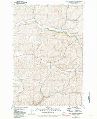
1981 Map of Little Penawawa Creek
USGS Topo · Published 1981About this map
Union Flat and the surrounding plateau of Whitman County define this agricultural landscape during the early 1980s. The map illustrates a region deeply tied to dryland farming, where the topography is carved by Union Flat Creek, Alkali Flat Creek, and Little Penawawa Creek. These watercourses dictate the placement of local infrastructure, from the small Cem tucked near a bend in the creek to the scattered Storage Bins that dot the hillsides.
Find a feature on this map
15 named features on this map. Tap any name to fly to it.
Don’t see what you’re looking for? This feature index may not catch every label — zoom into the map to look around manually.
Map Details
Editions of this 1981 Little Penawawa Creek Map
This is the sole edition of this map. No revisions or reprints were ever made.
Other maps of this area

1910 · Pullman
USGS Topo · 1:125,000

1950 · Penawawa
USGS Topo · 1:62,500

1950 · Endicott
USGS Topo · 1:62,500

1955 · Pullman
USGS Topo · 1:250,000

1958 · Pullman
USGS Topo · 1:250,000

1964 · Diamond
USGS Topo · 1:24,000

1964 · Wilcox
USGS Topo · 1:24,000
1964 · Almota
USGS Topo · 1:24,000

1981 · Dusty
USGS Topo · 1:24,000
1981 · Ping
USGS Topo · 1:24,000