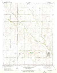
1970 Map of Little River
USGS Topo · Published 1976About this map
The Little Arkansas River carves a winding path across this Rice County landscape, defining the agricultural and industrial character of the region in the late 1960s. The Atchison Topeka and Santa Fe railroad serves as the primary artery for local commerce, connecting the township of Little River with smaller settlements like Galt and Mitchell. Evidence of the area's mid-century energy and mineral economy is visible through the Odessa Oil Field and the Crawford Oil Field, alongside a local quarry and several wells. A notable landmark in the village of Galt is the Townhall, situated near the rail line and river bend. The map also documents essential local infrastructure, including a Gaging Station on the river, a Water Tank, and a dedicated Sewage Disposal site, reflecting the organized development of these Kansas plains communities.
Find a feature on this map
21 named features on this map. Tap any name to fly to it.
Don’t see what you’re looking for? This feature index may not catch every label — zoom into the map to look around manually.
Map Details
Editions of this 1970 Little River Map
2 editions found
Other maps of this area

1891 · Hutchinson
USGS Topo · 1:125,000

1892 · Salina
USGS Topo · 1:125,000

1893 · Hutchinson
USGS Topo · 1:125,000

1894 · Ellsworth
USGS Topo · 1:125,000

1894 · Lyons
USGS Topo · 1:125,000

1942 · Salina
USGS Topo · 1:125,000

1955 · Great Bend
USGS Topo · 1:250,000

1955 · Hutchinson
USGS Topo · 1:250,000

1957 · Great Bend
USGS Topo · 1:250,000

1958 · Great Bend
USGS Topo · 1:250,000