
1891 Map of Little Rock
USGS Topo · Published 1891About this map
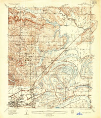
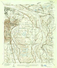
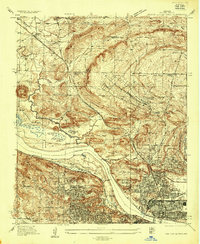
Little Rock serves as the focal point of this late 19th-century survey, positioned where the Arkansas River emerges from the highlands into the lower alluvial plains. Across the water from the capital city lies Argenta, surrounded by a complex network of bayous and oxbow lakes, including Rosenbaum Lake and Pears Lake. The landscape is defined by the convergence of major rail lines like the Little Rock and Fort Smith Railroad and the St. Louis Iron Mountain and Southern Railroad, which facilitated the regional transport of timber and agricultural goods.
Find a feature on this map
136 named features on this map. Tap any name to fly to it.
Don’t see what you’re looking for? This feature index may not catch every label — zoom into the map to look around manually.
Map Details
Editions of this 1891 Little Rock Map
This is the sole edition of this map. No revisions or reprints were ever made.
Other maps of this area

1890 · Benton
USGS Topo · 1:125,000

1892 · Morrillton
USGS Topo · 1:125,000

1893 · Little Rock
USGS Topo · 1:125,000

1894 · Morrillton
USGS Topo · 1:125,000

1894 · Benton
USGS Topo · 1:125,000

1932 · Pastoria
USGS Topo · 1:62,500
1935 · Mc Almont
USGS Topo · 1:24,000

1935 · Little Rock
USGS Topo · 1:24,000
1935 · Sweet Home
USGS Topo · 1:24,000
1935 · North Little Rock
USGS Topo · 1:24,000