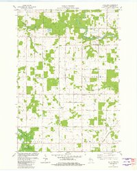
1981 Map of Little Rose
USGS Topo · Published 1982About this map
The Big Eau Pleine River winds through the northern reaches of this Marathon County landscape, where the settlement of March Rapids stands near a concentration of local infrastructure. This area features the Emanuel Ch and the Eau Pleine Cem, along with March Rapids County Park. The rural character of the region is defined by a grid of local roads like Mac Arthur Street and Balsam Street, serving scattered farmsteads and small clusters like Little Rose and Carlson.
Find a feature on this map
29 named features on this map. Tap any name to fly to it.
Don’t see what you’re looking for? This feature index may not catch every label — zoom into the map to look around manually.
Map Details
Editions of this 1981 Little Rose Map
This is the sole edition of this map. No revisions or reprints were ever made.
Other maps of this area

1902 · Marathon
USGS Topo · 1:125,000

1953 · Abbotsford
USGS Topo · 1:48,000

1953 · Stratford
USGS Topo · 1:48,000

1953 · Eau Claire
USGS Topo · 1:250,000

1954 · Granton
USGS Topo · 1:62,500

1954 · Marshfield
USGS Topo · 1:62,500

1958 · Eau Claire
USGS Topo · 1:250,000

1963 · Stratford
USGS Topo · 1:62,500

1963 · Abbotsford
USGS Topo · 1:62,500

1964 · Eau Claire
USGS Topo · 1:250,000