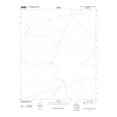
2010 Map of Little San Pascual Mountain
USGS Topo · Published 2010About this map
Little San Pascual Mountain rises above this arid stretch of Socorro County, New Mexico, marking a prominent landmark in a landscape defined by sparse desert ranching and remote transit. The settlement pattern is minimal, anchored by the presence of Bruton Ranch, which sits at a junction of backcountry routes. These corridors, identified as a156 and a153, provide the primary infrastructure for movement across the desert floor. Water resources in this environment are rare and critical, evidenced by the location of Shorty Tank. This 2010 survey reflects a modern era of land management where the traditional ranching heritage persists alongside the technological requirements of contemporary topographic mapping, capturing the intersection of topography and human persistence in the high desert.
Find a feature on this map
5 named features on this map. Tap any name to fly to it.
Don’t see what you’re looking for? This feature index may not catch every label — zoom into the map to look around manually.
Map Details
Editions of this 2010 Little San Pascual Mountain Map
This is the sole edition of this map. No revisions or reprints were ever made.
Other maps of this area

1948 · Carthage
USGS Topo · 1:62,500

1948 · Granjean Well
USGS Topo · 1:62,500

1948 · San Antonio
USGS Topo · 1:62,500

1948 · Val Verde
USGS Topo · 1:62,500

1954 · Tularosa
USGS Topo · 1:250,000

1958 · Tularosa
USGS Topo · 1:250,000

1981 · Granjean Well
USGS Topo · 1:24,000
1981 · Blakemore Well
USGS Topo · 1:24,000
1981 · Indian Well Wilderness
USGS Topo · 1:24,000
1981 · Harriet Ranch
USGS Topo · 1:24,000