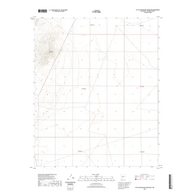
2020 Map of Little San Pascual Mountain
USGS Topo · Published 2020About this map
Little San Pascual Mountain dominates the western portion of this high desert terrain in Socorro County, anchoring a landscape marked by dramatic elevation changes. The land is primarily defined by the Public Land Survey System grid, including townships t6s r1e, t7s r1e, and t8s r1e, which indicate the systematic division of this New Mexico territory. Water sources are scarce in this arid environment, with Shorty Tank serving as one of the few named hydrological features in the northern reaches. This 2020 survey provides a clear view of the topographical contours and the network of primitive roads and trails that navigate the basin floor and mountain slopes east of the Rio Grande corridor.
Find a feature on this map
8 named features on this map. Tap any name to fly to it.
Don’t see what you’re looking for? This feature index may not catch every label — zoom into the map to look around manually.
Map Details
Editions of this 2020 Little San Pascual Mountain Map
This is the sole edition of this map. No revisions or reprints were ever made.
Other maps of this area

1948 · Carthage
USGS Topo · 1:62,500

1948 · Granjean Well
USGS Topo · 1:62,500

1948 · San Antonio
USGS Topo · 1:62,500

1948 · Val Verde
USGS Topo · 1:62,500

1954 · Tularosa
USGS Topo · 1:250,000

1958 · Tularosa
USGS Topo · 1:250,000

1981 · Granjean Well
USGS Topo · 1:24,000
1981 · Blakemore Well
USGS Topo · 1:24,000
1981 · Indian Well Wilderness
USGS Topo · 1:24,000

1981 · Harriet Ranch
USGS Topo · 1:24,000