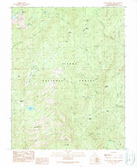
1990 Map of Little Shuteye Peak
USGS Topo · Published 1990About this map
Jones Store and several seasonal livestock outposts define the human footprint within the Sierra National Forest in this 1980s landscape. High-elevation meadows and grazing grounds like Muglers Meadow and Grizzly Meadow are connected by rugged corridors such as Beasore Road and Sky Ranch Road. The map documents the specific locations of several cow camps, including Topping Cow Camp and the sites of Kates Cow Camp and Swortzets Camp, reflecting the region's history of summer transhumance. Geological and recreational landmarks are prominent, from the distinctive Globe Rock to the granite heights of Little Shuteye Peak. Water is central to the area's geography, with the West Fork Chiquito Creek draining the central terrain and numerous alpine basins like Chilkoot Lake and Iron Lakes dotting the ridges. The inclusion of the McSwain Mine further highlights the varied resource use of this montane environment.
Find a feature on this map
43 named features on this map. Tap any name to fly to it.
Don’t see what you’re looking for? This feature index may not catch every label — zoom into the map to look around manually.
Map Details
Editions of this 1990 Little Shuteye Peak Map
2 editions found
Other maps of this area

1897 · Yosemite
USGS Topo · 1:125,000

1900 · Yosemite
USGS Topo · 1:125,000

1901 · Mt. Lyell
USGS Topo · 1:125,000

1903 · Yosemite
USGS Topo · 1:125,000

1904 · Kaiser
USGS Topo · 1:125,000

1909 · Yosemite
USGS Topo · 1:125,000

1912 · Mariposa
USGS Topo · 1:125,000

1947 · Mariposa
USGS Topo · 1:250,000

1948 · Mariposa
USGS Topo · 1:250,000

1953 · Merced Peak
USGS Topo · 1:62,500