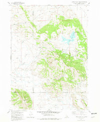
1981 Map of Little Valley Hills
USGS Topo · Published 1981About this map
Little Valley Hills rise prominently in this high-altitude landscape where Bingham, Bonneville, and Caribou counties converge. The settlement of Homer sits in the northern reaches, while the Little Valley Reservoir serves as a critical water management point for the surrounding drainages. The topography is defined by significant ridges like Wilson Ridge and Little Gray Ridge, separated by expansive level grounds such as Chubb Flat and the drainage of Crooked Creek. Land use is characterized by resource extraction and transit, evidenced by a Cinder Pit and a network of 4WD trails that navigate between summits like White Mtn and Limerick Mtn. This 1981 edition provides an essential view of the remote water systems and ranching terrain in Eastern Idaho before modern developments altered these rural corridors.
Find a feature on this map
25 named features on this map. Tap any name to fly to it.
Don’t see what you’re looking for? This feature index may not catch every label — zoom into the map to look around manually.
Map Details
Editions of this 1981 Little Valley Hills Map
This is the sole edition of this map. No revisions or reprints were ever made.
Other maps of this area

1914 · Henry
USGS Topo · 1:48,000

1915 · Lanes Creek
USGS Topo · 1:62,500

1916 · Henry
USGS Topo · 1:62,500

1917 · Cranes Flat
USGS Topo · 1:62,500

1932 · Irwin
USGS Topo · 1:96,000

1935 · Irwin
USGS Topo · 1:125,000

1955 · Driggs
USGS Topo · 1:250,000

1955 · Preston
USGS Topo · 1:250,000

1958 · Driggs
USGS Topo · 1:250,000

1958 · Preston
USGS Topo · 1:250,000