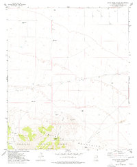
1974 Map of Little Wood Canyon
USGS Topo · Published 1977About this map
Mulkins Ranch sits at the base of the Chiricahua Mountains in this mid-1970s survey of Cochise County. The landscape is defined by the transition from arid desert flats to the steep topography of the Coronado National Forest, where drainage systems like Little Wood Canyon and Emigrant Canyon carve through the terrain. A clear network of water management features, including the East Windmill and Roosevelt Tank, illustrates the essential infrastructure required for ranching in this high-desert environment.
Find a feature on this map
19 named features on this map. Tap any name to fly to it.
Don’t see what you’re looking for? This feature index may not catch every label — zoom into the map to look around manually.
Map Details
Editions of this 1974 Little Wood Canyon Map
This is the sole edition of this map. No revisions or reprints were ever made.
Other maps of this area

1917 · San Simon
USGS Topo · 1:125,000

1926 · Cochise Head
USGS Topo · 1:62,500

1926 · Orange Butte
USGS Topo · 1:62,500

1928 · Chenoweth
USGS Topo · 1:62,500

1928 · Bowie
USGS Topo · 1:62,500

1949 · Bowie
USGS Topo · 1:62,500

1950 · San Simon
USGS Topo · 1:62,500

1950 · Bowie
USGS Topo · 1:62,500

1950 · Cochise Head
USGS Topo · 1:62,500

1950 · Vanar
USGS Topo · 1:62,500