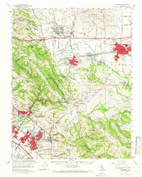
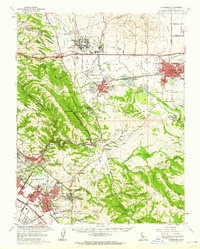
1961 Map of Livermore
USGS Topo · Published 1966About this map
Livermore and the Amador Valley are shown here during a period of rapid suburban and industrial expansion in the early 1960s. The landscape is a complex mix of agricultural heritage, evidenced by numerous wineries and the Alviso Adobe, and modern institutional growth. Large-scale installations like Camp Parks, the Santa Rita Rehabilitation Center, and the Vallecitos Atomic Laboratory represent the evolving land use in the hills surrounding Pleasanton. The map preserves the distinct identities of unincorporated communities and emerging districts such as Dublin, Sunol, and Kilkare Woods.
Find a feature on this map
128 named features on this map. Tap any name to fly to it.
Don’t see what you’re looking for? This feature index may not catch every label — zoom into the map to look around manually.
Map Details
Editions of this 1961 Livermore Map
2 editions found
Other maps of this area

1889 · San Jose
USGS Topo · 1:62,500

1896 · Mt. Diablo
USGS Topo · 1:62,500

1897 · San Jose
USGS Topo · 1:62,500

1897 · Mt. Hamilton
USGS Topo · 1:62,500

1897 · Concord
USGS Topo · 1:62,500

1897 · Palo Alto
USGS Topo · 1:62,500

1898 · Mt. Diablo
USGS Topo · 1:62,500

1899 · San Jose
USGS Topo · 1:62,500

1899 · Palo Alto
USGS Topo · 1:62,500

1899 · Haywards
USGS Topo · 1:62,500