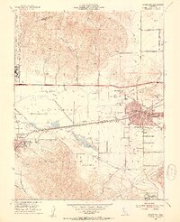
1953 Map of Livermore
USGS Topo · Published 1954About this map
Livermore and Pleasanton serve as the primary hubs in this early 1950s survey of the Livermore Valley. The landscape is transitioning from its agrarian roots toward a significant military and institutional presence, anchored by Parks Air Force Base and the Naval Auxiliary Air Field. Aviation history is well-represented through Livermore Sky Ranch and Dow Airport, while the industrial character is defined by Gravel Pits and the intersecting lines of the Southern Pacific and Western Pacific railroads. The map records several notable local landmarks, including the Livermore Sanitarium and the Santa Rita Rehabilitation Center Annex. In the outlying areas, local history is preserved in names like Kottinger Village, May Sch, and Eliot Siding, while several arroyos, such as Arroyo Mocho and Arroyo Valle, define the natural drainage of the valley floor.
Find a feature on this map
57 named features on this map. Tap any name to fly to it.
Don’t see what you’re looking for? This feature index may not catch every label — zoom into the map to look around manually.
Map Details
Editions of this 1953 Livermore Map
2 editions found
Other maps of this area

1896 · Mt. Diablo
USGS Topo · 1:62,500

1898 · Mt. Diablo
USGS Topo · 1:62,500

1906 · Pleasanton
USGS Topo · 1:62,500

1907 · Tesla
USGS Topo · 1:62,500

1911 · Byron Hot Springs
USGS Topo · 1:31,680

1916 · Byron Hot Springs
USGS Topo · 1:31,680

1916 · Byron
USGS Topo · 1:62,500

1940 · Byron
USGS Topo · 1:62,500

1941 · Pleasanton
USGS Topo · 1:62,500

1942 · Altamont
USGS Topo · 1:62,500