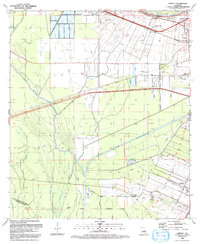
1992 Map of Lobdell
USGS Topo · Published 1992About this map
Gulf Intracoastal Waterway cuts through the lowlands of West Baton Rouge Parish, highlighting the engineering of the regional industrial and shipping corridor. In the early 1990s, the landscape was a blend of heavy infrastructure and small, established communities like Lobdell, Brusly, and Allendale. The influence of agriculture and early commerce is visible in the network of plantations and hamlets, while an Old Railroad line and numerous Pumping Stations speak to the area's logistical importance.
Find a feature on this map
34 named features on this map. Tap any name to fly to it.
Don’t see what you’re looking for? This feature index may not catch every label — zoom into the map to look around manually.
Map Details
Editions of this 1992 Lobdell Map
This is the sole edition of this map. No revisions or reprints were ever made.
Other maps of this area

1906 · Bayou Sara
USGS Topo · 1:125,000

1908 · Baton Rouge
USGS Topo · 1:62,500

1939 · Zachary
USGS Topo · 1:62,500

1939 · Baton Rouge
USGS Topo · 1:62,500

1940 · Grosse Tete
USGS Topo · 1:62,500

1953 · Baton Rouge West
USGS Topo · 1:24,000

1953 · Plaquemine
USGS Topo · 1:24,000

1953 · Lobdell
USGS Topo · 1:24,000

1953 · Addis
USGS Topo · 1:24,000

1953 · Grosse Tete SW
USGS Topo · 1:24,000