
Loading...
Loading map...1944 Map of Lock Haven
USGS Topo · Published 1944About this map
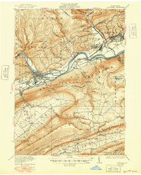
The Susquehanna River West Branch carves a deep valley through this 1944 survey, serving as the industrial and transit artery for Lock Haven. During this era, the town is a bustling hub anchored by the State Normal School and a significant rail junction where the New York Central Railroad meets the Pennsylvania Railroad. The presence of an Airport just east of the city limits reflects the growing regional infrastructure of the mid-20th century.
Find a feature on this map
80 named features on this map. Tap any name to fly to it.
Don’t see what you’re looking for? This feature index may not catch every label — zoom into the map to look around manually.
Map Details
Date Portrayed1944
Date Published1944
PublisherU.S. Geological Survey
Map TypeTopographic
Scale1:62,500
Physical Dimensions15.9 x 21.7 inches
Editions of this 1944 Lock Haven Map
This is the sole edition of this map. No revisions or reprints were ever made.
Historical Maps of Lock Haven Through Time
5 maps found

Featured Locations
Source Details
SourceU.S. Geological Survey
CopyrightPublic Domain