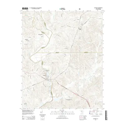
2014 Map of Lockhart
USGS Topo · Published 2014About this map
The Broad River and Pacolet River converge in this northern South Carolina landscape, creating a historical boundary where York, Cherokee, Union, and Chester counties meet. At the center of the river system lies Lockhart, situated along a bend in the river near Lockharts Upper Shoals and Lockhart Lower Shoals. For genealogists, the map identifies several significant burial sites, including the Bullock Creek Cem, Pinckney Cem, and the uniquely named Gist - Giles - Pinckneyville Cem near the settlement of Pinckney. Much of the southern terrain is dedicated to the Sumter National Forest, through which the Lockhart Hwy and Jonesville Lockhart Hwy provide transit. The presence of Loves Ford and Old Ferry Rd suggests longstanding river crossings that once linked these isolated rural communities across the shifting shoals of the Broad River.
Find a feature on this map
81 named features on this map. Tap any name to fly to it.
Don’t see what you’re looking for? This feature index may not catch every label — zoom into the map to look around manually.
Map Details
Editions of this 2014 Lockhart Map
This is the sole edition of this map. No revisions or reprints were ever made.
Other maps of this area

1907 · Sharon
USGS Topo · 1:62,500

1941 · Spartanburg
USGS Topo · 1:250,000

1953 · Spartanburg
USGS Topo · 1:250,000

1960 · Spartanburg
USGS Topo · 1:250,000

1963 · Spartanburg
USGS Topo · 1:250,000

1964 · Spartanburg
USGS Topo · 1:250,000
1968 · Wilkinsville
USGS Topo · 1:24,000

1969 · Kelton
USGS Topo · 1:24,000

1969 · Baton Rouge
USGS Topo · 1:24,000
1969 · Leeds
USGS Topo · 1:24,000