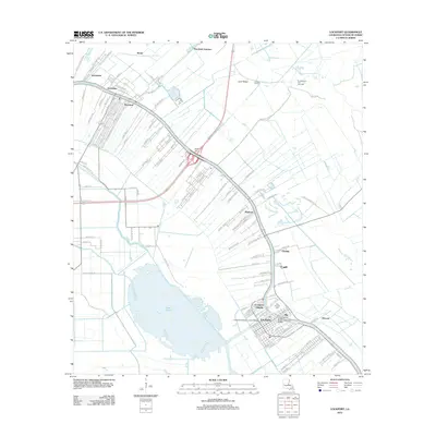
2012 Map of Lockport
USGS Topo · Published 2012About this map
Bayou Lafourche serves as the primary spine of development through this coastal Louisiana landscape, dictating the narrow, linear settlement patterns that define the region. The town of Lockport and nearby Lockport Heights sit at a strategic bend in the bayou, connected by the Lockport Bayou Lafourche Bridge. To the northwest, the community of Raceland and the Godchaux area illustrate the transition from agricultural roots to modern industrial utility, further evidenced by the Raceland Oil and Gas Field to the northeast. Beyond the populated banks, the terrain opens into the expansive waters of Lake Fields and the complex network of the Bayou Cut-Off and Bayou Joliet. Family-named landmarks such as Hadley Cem and small settlements like Clotilda and Mathews offer valuable points of reference for genealogists tracing local lineage in Lafourche Parish.
Find a feature on this map
128 named features on this map. Tap any name to fly to it.
Don’t see what you’re looking for? This feature index may not catch every label — zoom into the map to look around manually.
Map Details
Editions of this 2012 Lockport Map
This is the sole edition of this map. No revisions or reprints were ever made.
Other maps of this area

1891 · Hahnville
USGS Topo · 1:62,500

1892 · Lac Des Allemands
USGS Topo · 1:62,500

1892 · Cut-Off
USGS Topo · 1:62,500

1892 · Houma
USGS Topo · 1:62,500

1932 · Houma SE
USGS Topo · 1:31,680

1932 · Lac Des Allemands SE
USGS Topo · 1:31,680

1932 · Lac Des Allemands SW
USGS Topo · 1:31,680

1932 · Houma SW
USGS Topo · 1:31,680

1932 · Houma NE
USGS Topo · 1:31,680

1932 · Houma NW
USGS Topo · 1:31,680