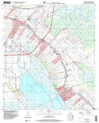
1998 Map of Lockport
USGS Topo · Published 2000About this map
Bayou Lafourche anchors the settlement pattern of this coastal Louisiana corridor, where ribbon-like communities follow the higher ground along the banks. In the late 1990s, the landscape from Raceland down to Lockport illustrates a transition from industrial hubs to residential pockets. The central Bayou Cutoff and a network of drainage structures, including numerous Pumping Stations and the Forty Arpent Canal, manage the water for the surrounding lowlands. This survey documents the local infrastructure of the era, from the Raceland High Sch and the Assembly of God Ch to the expansive Lake Fields and Grand Bayou to the west. The layout of Mathews, Clotilda, and Lockport Heights reveals how historical land grants and the sugar-cane-derived settlement patterns persisted even as modern industrial features like the Oil and Gas Field and Waste Ponds were established.
Find a feature on this map
41 named features on this map. Tap any name to fly to it.
Don’t see what you’re looking for? This feature index may not catch every label — zoom into the map to look around manually.
Map Details
Editions of this 1998 Lockport Map
This is the sole edition of this map. No revisions or reprints were ever made.
Other maps of this area

1891 · Hahnville
USGS Topo · 1:62,500

1892 · Lac Des Allemands
USGS Topo · 1:62,500

1892 · Cut-Off
USGS Topo · 1:62,500

1892 · Houma
USGS Topo · 1:62,500

1932 · Houma SE
USGS Topo · 1:31,680

1932 · Lac Des Allemands SE
USGS Topo · 1:31,680

1932 · Lac Des Allemands SW
USGS Topo · 1:31,680

1932 · Houma SW
USGS Topo · 1:31,680

1932 · Houma NE
USGS Topo · 1:31,680

1932 · Houma NW
USGS Topo · 1:31,680