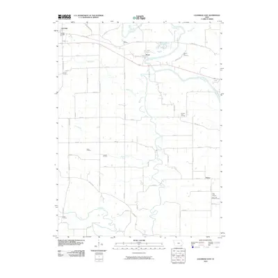
2010 Map of Lockridge East
USGS Topo · Published 2010About this map
Skunk River meanders through this portion of Jefferson County, defining the rural landscape between the towns of Lockridge and Rome. This 2010 survey reveals a densely recorded genealogical landscape, featuring an unusual concentration of burial sites such as the Cholera Hill Cemetery and the Cedar Creek Friends Cemetery. The presence of the Lockridge Post Office and the small settlement of Denova near the eastern edge anchor the local road network. The terrain is deeply inscribed by watercourses including Wolf Creek, Cedar Creek, and Berry Branch, which likely dictated the early patterns of agricultural settlement and road placement throughout the township. These labels provide precise locations for researchers tracing family history or early Iowa homesteads along the established corridors of Old Hwy 34 and the surrounding section lines.
Find a feature on this map
52 named features on this map. Tap any name to fly to it.
Don’t see what you’re looking for? This feature index may not catch every label — zoom into the map to look around manually.
Map Details
Editions of this 2010 Lockridge East Map
This is the sole edition of this map. No revisions or reprints were ever made.
Other maps of this area

1958 · Burlington
USGS Topo · 1:250,000

1958 · Davenport
USGS Topo · 1:250,000

1961 · Burlington
USGS Topo · 1:250,000

1961 · Davenport
USGS Topo · 1:250,000

1962 · Davenport
USGS Topo · 1:250,000

1963 · Burlington
USGS Topo · 1:250,000

1980 · Lockridge West
USGS Topo · 1:24,000

1980 · Trenton
USGS Topo · 1:24,000
1980 · Salina
USGS Topo · 1:24,000

1980 · Lockridge East
USGS Topo · 1:24,000