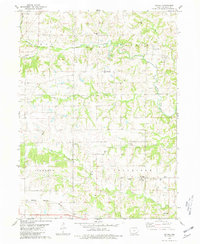
1980 Map of Salina
USGS Topo · Published 1981About this map
Salina and Germanville anchor this rural Jefferson County landscape, where the pattern of small-town settlement is deeply tied to the local watercourses and early ecclesiastical history. The map highlights a significant religious and cultural heritage, particularly evident in the cluster of institutions such as the New Sweden Lutheran Ch, New Sweden Baptist Ch, and New Sweden Cem. These landmarks, along with family and community sites like Polishville Cem and Lower Richwoods Cem, provide a precise record of the area's 19th-century immigrant roots. The southern portion of the quadrangle is defined by the Burlington Northern railroad corridor passing through Beckwith, while the drainage of Walnut Creek and Brush Creek dictates the topography of the surrounding farmland and several active Quarry sites.
Find a feature on this map
25 named features on this map. Tap any name to fly to it.
Don’t see what you’re looking for? This feature index may not catch every label — zoom into the map to look around manually.
Map Details
Editions of this 1980 Salina Map
This is the sole edition of this map. No revisions or reprints were ever made.
Other maps of this area

1958 · Burlington
USGS Topo · 1:250,000

1958 · Davenport
USGS Topo · 1:250,000

1961 · Burlington
USGS Topo · 1:250,000

1961 · Davenport
USGS Topo · 1:250,000

1962 · Davenport
USGS Topo · 1:250,000

1963 · Burlington
USGS Topo · 1:250,000
1980 · Fairfield North
USGS Topo · 1:24,000
1980 · Richland
USGS Topo · 1:24,000

1980 · Brighton
USGS Topo · 1:24,000
1980 · Fairfield South
USGS Topo · 1:24,000